Please send your comments to Simon Norton
Associated documents (N.B.: map 3 is not included):
Under the Road Traffic Reduction Bill, now going through Parliament, county, district and unitary councils would have a duty to set targets for reducing traffic levels in their areas and produce plans showing what measures were, in their opinion, required to meet those targets. Town and parish councils would also have powers to produce Traffic Reduction Plans.
We believe that a traffic reduction programme would bring considerable benefit to the people of Cambridgeshire, just as to the rest of Britain, by cutting pollution, curbing car dependence and giving people without cars better access to facilities.
However, we also believe that car dependence has become so entrenched in Cambridgeshire (and elsewhere in Britain), and the public transport network so disintegrated, that radical measures are required both locally and nationally to achieve any meaningful traffic reduction targets. It is the object of this report to set out all the measures which we believe should be considered by Cambridgeshire CC and other local authorities within the county for inclusion in a Traffic Reduction Plan. While they might not consider all our proposals appropriate, we believe that any substantially less ambitious plan is unlikely to succeed.
Our top priorities for the County are to develop a county-wide integrated public transport network to the minimum standards suggested in 4.3; to lobby for such change in national and European policies as would be required to achieve this and to take forward other traffic reduction policies (Section 5); and to try to stop any developments that might make the situation worse (4.5).
It is widely thought that bus services have declined to the extent to which it would be hopelessly expensive to revive them. We believe this is false. What is needed is to amalgamate existing public transport facilities (both bus and rail), with selective improvements, into a network. Such a network should be able to cater for a large proportion of the journeys now made by car. While, for many such journeys, the car would still offer greater convenience, we suggest that fiscal incentives would make public transport the preferred option, and the problem lies mainly in the exaggerated and unsustainble expectations which most motorists have of a car-based transport system.
This report was compiled by Transport 2000 Cambs & W Suffolk with assistance from Cambridge Friends of the Earth, the Cambridgeshire branch of the Council for the Protection of Rural England, Sustainable Transport & Environment in the Eastern Region (STEER) and Wisbech Friends of the Earth, which we gratefully acknowledge.
Simon Norton, Coordinator, Transport 2000 Cambs & W Suffolk
This is the title of a Bill drafted jointly by Friends of the Earth and the Green Party, and introduced into Parliament as a Private Member's Bill. The Second Reading was on 24 Jan 1997. The Bill is supported by Cambridge MP Anne Campbell, Cambridge City and Cambridgeshire County councils, at least eight parish councils within Cambridgeshire, and several neighbouring district councils.
1.1. In its original form - which the promoters of the Bill would still like to get onto the statute book in due course - the Bill would have required both national and local government to draw up traffic reduction plans with the aim of reducing traffic from 1990 levels by 5% by 2005 and 10% by 2010. Local authorities would have to say what they thought was necessary to achieve these targets; the Government would have to finance any extra spending that would be required (i.e. over and above what might be saved by measures such as cutting the road-building programme), and to issue an annual report on the progress of local and national measures required to achieve these targets. The principal change between this and the version now going through Parliament is to delete the national traffic reduction targets in favour of locally set targets.
1.2. Even so, the significance of the Bill is that the Government would come under pressure to listen to local authorities and to implement such legislative and other changes as local authorities deemed necessary. In other words, local authorities would no longer have to watch helplessly while the Government introduced measure after measure preventing them from doing what was needed.
1.3. Even though Cambridgeshire CC has declared its support for the Bill, there is little in current County Council policies that is likely to reduce the rate of traffic growth significantly, let alone to reduce traffic. This is partly because of Government restrictions on their activities; but, on their current record, we believe that the Council has to a large extent internalised Government values, that is, many of their members and officers have stopped thinking outside the constraints imposed by the present Government, and would have little idea how to set about providing a satisfactory alternative to the car for the vast majority of journeys. It is the purpose of this report to fill this gap.
1.4. The report is not intended to be prescriptive; in other words, we are not claiming that every measure listed is necessary. However, we do believe that action on a wide front is necessary, and the proposals in this report are intended as illustrations of the kind of actions that are needed. We do not intend to estimate how much of our programme is necessary to achieve the national targets in the original version of the Bill - our attitude is that the more we can reduce traffic without injurious side effects the better. In any case these targets are not intended to apply uniformly to every part of the country; it would probably be unrealistic to apply them to ``growth centres'' in rural areas, for example. However, the Bill's aims are not restricted to reducing urban traffic, and it is intended that local authorities in rural areas such as most of Cambridgeshire should do what they can to stem rural traffic growth. Official traffic forecasts (which assume a ``no change'' policy) predict a fourfold increase in rural traffic levels between 1990 and 2025; so, if the national targets are to be met, rural local authorities must pull their weight. The disbenefits of traffic enumerated in Section 2 amply justify such a policy.
Many of the following arguments have seen a lot of publicity in recent years and should be familiar to most readers, but others will be less familiar.
2.1. Air quality. Fumes produced by both petrol- and diesel-fuelled vehicles are not only unpleasant but detrimental to people's health and to the environment. Emissions dangerous to health include nitrogen oxides, carbon monoxide, hydrocarbons, lead and particulates. Nitrogen oxides in particular cause respiratory problems over a wide area by catalysing the production of low level ozone - and they are also one of the pollutants in acid rain, which is implicated in the decline of forests, lakes and other ecosystems. The Government's initiatives on air quality include ``technical fixes'' for most of these pollutants. However, official estimates indicate that such fixes will not be effective in the medium term if traffic continues to grow - and they will be totally ineffective in respect of the other disbenefits of traffic as listed in this section.
2.2. Global Warming. The principal cause of global warming is carbon dioxide. This does not impair air quality, and is therefore not included in the Government's air quality strategy. However, the consequent rise in sea levels is likely to have disastrous effects on low lying areas, especially in poorer countries that cannot afford coastal protection. Incidentally, one effect of global warming may well be to make British winters colder, by changing the pattern of ocean currents and so weakening the Gulf Stream that makes our climate exceptionally equable.
2.3. Noise. In the most heavily trafficked areas people may be unable to get to sleep. Even when they can get to sleep, the quality of their sleep (and, therefore, their performance when awake) may be impaired by background noise. The need to keep windows closed to keep noise out can be a source of considerable discomfort, especially in summer. According to a 1993 report, a majority of people are subject to night noise levels exceeding World Health Organisation guidelines.
2.4. Danger. Traffic is now the most important cause of death in certain age groups. The fear of traffic forces many parents to keep their children at home, thereby hindering the social interaction necessary to their development. Such parents may also find their lives constrained because they have to transport their children wherever the latter need to go. Old people, whose reactions tend to be slower, are liable to be intimidated by traffic. It is also likely that crime and vandalism are more likely to flourish in a car-based culture where street life is minimal.
2.5. Intrusion. Life in many towns and villages is already intolerable due to excessive traffic. The main current reaction to this problem is to build by-passes. Such by-passes generate more traffic and are therefore no long term solution. New roads also threaten many valued areas of countryside - for example numerous Sites of Special Scientific Interest lie in the paths of currently planned routes. In addition, roads and car parks eat up vast areas of land thereby squeezing out alternative uses and encouraging urban sprawl.
2.6. Congestion. Hold-ups to traffic lead to uncertainty in how long a given journey is likely to take. This is particularly damaging to buses, as the effects of any delay will be felt throughout the route, and considerable inconvenience may be caused by the missing of connections. For the cost to industry, a 1995 CBI report quotes an annual figure of $19 billion.
2.7. Social inequity. Dependence on cars leads to a decline in public transport, and to increased costs in supporting such public transport as continues to run. It also encourages the location of facilities away from convenient access by public transport, or by walking and cycling. These two factors put together mean that people without independent access to cars - a majority of the population - may have difficulty in fulfilling their needs and desires.
2.8. Waste of resources. As a result of dependence on cars, a high proportion of our national economy is devoted to supporting the high level of car ownership. What could not be achieved if these resources were redirected to more worthy causes?
2.9. Escort costs. Parents are having to spend increasing amounts of time escorting their children, not only to school but also to after-school activities, because of worries about the safety of their children travelling alone - one operator (National Express) even refuses to accept unaccompanied children. This may act as a significant curb on their own leisure activities. Lack of public transport, or unsafe streets, also means that pensioners need escorts even for essential activities like shopping, and people who have been drinking need to be taken home.
The purpose of traffic reduction is to cut the above costs of traffic, and for the most part the measures we are proposing will both reduce traffic and cut its costs. Where there is a conflict between the two we are giving priority to the latter.
3.1. New developments. Cambridgeshire has been one of the fastest growing counties in Britain. Housing has been concentrated in villages in South Cambridgeshire, throughout Huntingdonshire district and within the city of Peterborough. Industry has been concentrated on edge of town sites, of which the best known is the Cambridge Science Park, and in villages. Supermarkets have been built on out of town sites, and many more have planning permission.
People who live in villages are not unlikely to use public transport to travel to work or shopping in the centre of a city like Cambridge, except when they have access to private parking. But they will have no reason to do so when travelling to edge of town or village sites, and even if they wanted to do so facilities are unlikely to be available unless the live on the right corridor. So there has been a massive expansion of traffic in the Cambridge and Huntingdon areas, causing peak hour congestion in many places.
Despite the rise in population, village shops are far from flourishing as newcomers mostly use the new superstores. In-town shopping in places like Cambridge has also declined. As villagers without a car are unlikely to have ready access to areas other than their home village and central Cambridge, the combination of these two trends has significantly exacerbated car dependence.
3.2. New roads. Recent years have seen the upgrading of the A14 corridor to dual carriageway throughout, allowing uninterrupted travel by car between East Anglia and the Midlands. In theory this could have been accompanied by comparable improvements in public transport - say, a rail-linked bus service (see S4 in Part C) - which would have cut journey times for public transport users on this corridor. In practice such a service has not materialised, and existing buses on the A14 corridor do not, for example, provide an adequate day trip facility from Cambridge to the Midlands.
More recently work has started on upgrading the A1 between Alconbury and Peterborough to motorway. This is proceeding under the controversial DBFO system whereby the private developer pays to build and operate the road in return for a payment from the taxpayer for every vehicle that uses it. DBFO has been strongly criticised as more costly than conventional financing, and likely to lead to corruption as the developer has a financial interest in the provision of developments that will generate traffic on the road. Meanwhile, proposals to upgrade adjacent sections of the A1 have been dropped, so if enough traffic is generated to ``justify'' the motorway the likely result will be to overload the rest of the county's roads.
3.3. Public transport. As a result of electrification and population increases, train services to London have generally improved (though there are exceptions, e.g. the withdrawal of most Inter-City trains from Huntingdon). The introduction of Sprinters improved cross-country services too, though at the expense of those who wish to take bicycles with them (a complaint which is now being dealt with under the ``Cycle Challenge'' scheme). However, late night trains (except from London) have been cut, and Sunday trains are no longer suitable for day trips to the seaside.
As for buses, some strategic routes have seen improvements (Cambridge to Oxford and the London airport system) while others have been cut, such as Cambridge to London via the A10 corridor (see C15) and Peterborough to Nottingham (see P6). The same is generally true of more local services. But recently there has been a definite downward trend, as (mostly rural) services are cut by both the County Council and commercial operators.
3.4. Tourism. The number of tourists visiting Cambridge has continually risen. This is one of the factors that has led to the closure of many traffic-free walking routes through the colleges, initially for a short period each year to reduce disturbance to students during the examination period, but now on a permanent basis and linked to visitor charging schemes.
Though it is official policy to encourage tourists to visit other parts of the county, nothing has been done to provide systematic information on how to do this by public transport. So it isn't surprising that the majority of visitors arrive by car.
3.5. Security. In line with national trends there has been a dramatic rise in the tendency for people to feel that they are putting themselves in danger by walking on their own at night.
In general, there are two types of measure for reducing traffic, which can be described as the ``stick'' and the ``carrot''. ``Stick'' type measures will make it more expensive or less convenient for people to drive; ``carrot'' type measures will make alternative modes of transport cheaper or more convenient.
4.1. Any traffic reduction plan incorporate both types of measure. If we go for the stick alone, considerable hardship will be caused to many people who currently have no alternative, long before a significant proportion of motorists have been persudaded to use other modes of transport or to travel less. If we go for the carrot alone, lots of money will have to be spent on improved rail and bus services that will not attract significant usage as long as motoring remains relatively cheap. It is the combination of the stick and carrot that provides the effective and self financing policy mix we need.
4.2. This suggests a general strategy of giving priority to measures which will give the vast majority of people an effective alternative to the car for most of their mileage. As it is rural areas where car dependence is highest, this means that improving rural public transport should be a priority.
There are two other arguments for pursuing such a policy. One is social: there are still many people who live in rural areas or who wish to travel to or through them, but who do not have independent access to a car; depriving these people of efficient public transport effectively means denying them the right of full participation in society. The second is practical: if one adopts a traffic reduction policy that is solely focused on urban areas then there will be more and more pressure for facilities to move out of town to places beyond the scope of such policies and poorly accessible except by car - which will lead to yet more traffic. Both these trends are clearly visible at present.
4.3. As a recent report of the Round Table on Sustainable Development has shown, present public transport provision is little more than a joke, and it is not surprising that many people are not prepared to give it serious consideration. We therefore propose the following standards as a first step. It is arguable whether they will be enough on their own to provide a satisfactory alternative to the car; we believe that they would, but if they aren't enough it is even more necessary to implement radical improvements as soon as possible. Yes, our proposals are unashamedly ambitious - but we are sure that anything markedly less ambitious is unlikely to have any real impact.
4.3.1. The strategic network. This is the public transport equivalent of the trunk road network. It should aim to provide routes for long distance travel in every direction out of every main regional centre, including direct links with all neighbouring main and subsidiary regional centres. All principal towns should be on the network. Also every main regional centre should have a link to Europe with at most one change. Where possible, rail would be used for strategic services, and there should be a long term aim of extending this to as many corridors as possible. All services should carry bicycles. Each services should run at least 2 hourly, 7 days a week and evenings included, and overall frequencies on a corridor should normally be hourly. A proposed strategic network is given in Section S (Part C).
In the context of this proposal, within Cambridgeshire, Cambridge and Peterborough are main regional centres; Huntingdon and Wisbech are subsidiary regional centres; and the other principal towns are Ely, March, St Neots and St Ives.
4.3.2. The primary network. As the name suggests, this is the public transport equivalent of the primary road network. It should aim to link every town with all neighbouring main and subsidiary regional centres, and every principal village with a main regional centre. Services should run at least 2 hourly, and where possible hourly, throughout the main daytime period on weekdays; in those parts of the county where London commuting is common there should be an early evening link connecting off a London train; and sufficient evening and Sunday services should be provided to cover every town and to give every village a service within walking or cycling distance by a safe route. The last bus to any village should connect with an incoming train. Also, at weekends (especially in summer) every significant visitor attraction should be served, and there should be facilities for day trips to the seaside.
A ``principal'' village is one which has seen large scale new development, or in which future development, of whatever size, other than for purely local needs, is allowed.
4.3.3. The urban network. This should aim to provide services every 15 minutes to every neighbourhood of a main regional centre, and to the main villages in the surrounding area. The latter would also fulfil a Park & Ride role (see 10.2). Evening and Sunday buses should be at least hourly and preferably half hourly. Neighbourhoods of subsidiary urban centres should have at least a half hourly daytime service and be within walking distance of evening and Sunday buses.
4.3.4. The local network. This should aim to give every village access to a nearby town at times suitable for schoolchildren, workers and shoppers; to provide direct services between every pair of neighbouring towns; and to satisfy other needs not provided for by the strategic and primary networks.
4.3.5. Network coordination. The above services should be planned with a view to optimising connections (easy transfer between services, low waiting times, through ticketing where possible). There should also be comprehensive publicity and marketing at three levels: to make people (including visitors to the region) aware of the extent of their journey opportunities; to give easy access to printed information enabling people to plan their own journeys; and to provide a 24 hour telephone information service which also covers late changes (e.g. alterations to rail or bus services due to infrastructure work).
4.4. As such a network is being set up fares should be reduced to a level where it would pay most motorists to use public transport where possible. We believe this can be done in such a way that almost all motorists, even in rural areas, can satisfy all their travel needs at less cost than at present by driving less. (Even for journeys needing a car they may opt to drive to a suitable intermediate interchange point rather than to their destination.) Thus hardship would no longer be a valid reason for not taxing motorists in accordance with the full costs they impose on society.
There have been various estimates of such costs. For example, ``Death on the Streets'' by Robert Davis suggests that a typical car owner pays $1200-4200 less in tax than the cost of the car to society. It is such increased taxation that would be used to finance the initial costs of seeting up an integrated transport system, and the rest of the traffic reduction plan - and there should be plenty left over to cut other taxes or prices. The last would help sell the policy to the public on the basis that most people would not feel worse off as a result.
4.5. If setting up an integrated public transport network is a priority, taking immediate action to halt or mitigate unsustainable developments is another. Such developments include road schemes, car-based housing, shopping or industrial developments, and anything at all that encroaches on a rail route that may be needed in future (see Section S of Part C for details). Note that routes outside Cambridgeshire may also need protection (e.g., for proposal S10, land within Hertford and Hitchin). National and/or local government should try to persuade developers to abandon their ideas in favour of alternatives that would be more sustainable and equally profitable (especially within the context of a traffic reduction strategy).
Here are the main policy changes which we believe the Council should lobby for at the national and European levels. These underpin most of the local recommendations of this report.
5.1. Increase national and introduce European taxes on cars, lorries and aviation. As mentioned in 4.4, the revenue from this could be used to support whatever higher spending (nationally or locally) was found to be necessary. See also Section 8. Though aviation is outside the scope of the Road Traffic Reduction Bill, it does cause significant pollution, and it is at present anomalous in that it escapes fuel tax entirely.
5.2. Stop the tight squeeze on local authority transport spending. This is, of course, part of the overall squeeze on local authorities. This is intended to cover revenue as well as capital spending. The case for a more general relief from the spending squeeze is outside the scope of this report, but it is worth making the point that many local authorities have authorised unsustainable developments because this has been the only way they could finance locally needed facilities (of whatever kind).
5.3. Reduce public transport fares. As mentioned in 4.4, in conjunction with 5.1 this would encourage people to use public transport, instead of driving, for all journeys for which it was suitable. The Government could achieve this by means such as general subsidies, matching local authority subsidies, or tax incentives (see 11.4, for example, which would also require a universal season ticket system).
5.4. Amend the Highway Code to improve the rights of pedestrians and cyclists. For example, pedestrians should normally have priority over turning traffic at lights, as is common in other countries. Of course such changes would have to be well publicised so that drivers were aware of them.
5.5. Set up a national network of Transport Authorities. These should be directly or indirectly elected with powers and duties to coordinate local rail and bus services. The reason for this proposal is that it would otherwise be very difficult to achieve the standards of 4.3. The proposed system is not unlike that now operating in London, where London Transport specifies most bus and underground services and franchises the former to operators - but LT isn't democratically accountable and doesn't control main line rail services. Transport authorities could be based on the 1974 counties (it is important not to segregate cities into unitary authorities) or on regional government.
5.6. Make it easier for local authorities to create new pedestrian and cycle routes over private land. Such legislation should pay due regard to the interests of landowners and offer them incentives to cooperate. This would not only encourage walking and cycling but also reduce the exposure of walkers and cyclists to pollution by giving them the option (which should not be compulsory) of not using the roads.
5.7. Give powers to local authorities to deal with local problems. This might involve measures such as road pricing, area-wide parking restrictions and enforceable speed limits. See also Section 10.
5.8. Allow domestic passengers on Eurostar trains. This would make rail more efficient by enabling domestic Inter-City services to be integrated with the international network. This would make it easier for rail to compete with air (see 5.1).
5.9. Reduce the desire for cars. Measures which might accomplish this at both national and local level include controls on car-related advertising, teaching public transport skills in schools, allowing and encouraging children to explore their environment on their own, requiring advertisers of particular locations (such as tourist leaflets) to include public transport information, and trying to reduce people's expectations of the transport system to what is sustainable.
We now give some of the measures needed to achieve the goals of 4.3.
6.1. Fill the gaps in the strategic and primary network. At present the strategic network provides reasonably adequate facilities on some corridors (e.g. Cambridge to London), but others (e.g. Cambridge to mid Essex, see S6, S10 and C15) are dependent on chance connections between local services; while on yet others (e.g. Peterborough to Northampton, see S5 and S11) services are slow, and/or non-existent in the evenings and on Sundays. There are also gaps in the primary network, notably Warboys to Chatteris (see H7) and Cambridge to East Bedfordshire (see C14).
6.2. Provide adequate interchanges and connections. People living off the strategic network need to be given access to it by means of connecting services. For example, Cambridgeshire is near enough to London for people to be entitled to expect day trip facilities, and this requires direct links from villages to suitable rail stations at suitable times - in particular, in the evenings so that people can travel out after the morning peak and still have a reasonable amount of time in London. This is one reason for our goal (see 4.3.2) that late night buses should connect with suitable incoming trains. Such connections should be guaranteed in the sense that if the train is late, and the bus cannot wait for it, then the passenger can rely on a ride home by some other means at no extra cost. Also, the different buses serving a given school or workplace can be arranged to connect with one another so as to offer passengers a wide variety of journey opportunities; and times for buses on the local network should be arranged to enable people to venture further afield, perhaps returning home (or having come out) on a school bus.
6.3. Consolidate the bus network. The above two recommendations deal with longer distance journeys. But most journeys are short. The viability of the public transport network can be considerably improved by designing services for multi-purpose use. Here are some ways of making services more versatile: stopping express coaches at local stops on the line of route (unless adequately served by other routes); allowing the general public to use school and works buses, and positioning workings en route to/from bus depots; timing rural services to optimise connections with the strategic network; using conventional buses, rather than ``dedicated'' services, for park & ride (see 10.2); adapting the network to serve both places that are important as origins (population centres, interchanges) and destinations (town and city centres, leisure facilities, hospitals, industrial estates, interchanges). Other recommendations are to open up missing links and to link services to minimise the need for changes.
6.4. Make the network easy to use. As much as possible of the strategic and primary network should be organised on the ``regular interval'' principle, so that times are easy to remember and connections easier to organise. Timetable changes should be announced at fixed dates, so people can be sure their information is up to date. Timetables or departure times should be posted at all stops. Comprehensive area-wide timetables should be published whenever services change, and should be continuously available from a wide range of local outlets. Local guides should be produced for each city and town giving details of how to get to the most important destinations within the region by public transport (including leisure and tourist attractions).
6.5. Keep fares down and reduce boarding delays due to fare collection. For the first see 4.4. The second would help to make buses competitive with cars in terms of journey time. It would involve simplifying the fare system and providing a wide range of through and unlimited travel tickets which may be sold off the bus.
6.6. Franchises should be on a ``minimum cost'' basis. This means that the local transport authority (see 5.5), rather than the operator, keeps the revenue from passengers. This has two advantages: it avoids problems with allocating revenue from multi-operator tickets, and it means that the cost to the public purse of traffic reduction measures can be offset by increased public transport revenue. It is, however, reasonable to allow operators to fill gaps in the transport authority network (where they exist) on a commercial basis, and to encourage them to invest in their own franchises on a partnership basis, i.e.\ in return for a share of the generated revenue.
6.7. Consult users about proposed changes. This is difficult under the present system, though we believe the County Council could do a lot more than it is doing.
6.8. Consider options for rapid transit developments (light rail and guided bus). The experience of the German city of Karlsruhe shows that trams and main line trains can safely share tracks, though we do not regard such a development as other than a long term possibility. It would require that relevant stretches of main line railway be provided with Automatic Train Protection. We also believe that there may be a role for guided buses, though not on the Cambridge to St Ives line for which they are currently being mooted (as this corridor is needed for a conventional rail link).
6.9. Open new stations. The purpose of this is to increase the proportion of journeys for which the rail network is suitable. It is important to note that the more stations there are, the greater the benefit from a particular new station; so considering each new station proposal in isolation will understate the overall benefit from such a programme. New stations can be divided into four types: stations to serve projected new developments, stations to serve ``destinations'', stations to serve fair sized communities, and stations to serve small communities which are, however, remote and difficult to serve by bus. All the stations we are proposing below fall into one or more of these categories.
6.10. Improve on-bus communications. The ability of drivers to communicate by mobile phones or other means can be of great importance, e.g. to safeguard connections or to fetch help in emergencies. This would also enable passengers (via a central base) to find out what was going on when their bus hasn't turned up.
The majority of journeys are well within the distance people can walk or cycle. The following measures would encourage people to use these modes.
7.1. Provide a network of routes away from traffic. At present Sustrans is developing a Millenium National Cycle Network providing inter-urban links throughout the county (and elsewhere). This is based on a mixture of off-road routes (which remove people completely from the danger, stress and local pollution caused by road traffic) and lightly used roads where the impact of traffic is minimised by measures such as cycle-friendly traffic calming. We recommend that the network should be extended as necessary to fulfil the standards of 4.3.2. Proposal 5.6 would make it easier to adapt and extend the existing rights of way network. In towns, where traffic is usually heavier, available open space should be exploited to provide ``greenway'' routes. Routes should be of high quality (e.g. surfacing) and existing routes need improving in this respect.
7.2. Make streets and open spaces safer. At present, many people are inhibited from walking or cycling along public highways because of fear of either traffic or street crime. Or parents may worry about their children being run over or abducted. The ``crime'' factor also leads to avoidance of open spaces. This is one of the most powerful incentives to car use, and it is crucial that this be tackled. Such fears are partly based on the reality of increasing crime levels and partly psychological - perhaps due to over-reporting by the media; in either case we need to improve neighbourhood policing enough to reassure people.
The feeling of vulnerability is a vicious circle; if some people desert the streets and open spaces because of fear of crime, others will feel less safe as a result. Contrariwise, if more people walked or cycled, everyone would feel safer - and this should be our aim. Particular attention should be given to making people feel more secure on open spaces, where current feelings of vulnerability are largely due to over-dependence on cars.
7.3. Give more priority to pedestrians and cyclists on main roads. In particular, people should not be subject to long waits at light controlled crossings (we would like to see zebra crossings whenever possible), and people should be able to negotiate an interchange without having to hang around on traffic islands and inhale noxious pollutants. Proposal 5.4 would help here.
At present there is a tendency for cycle routes to stop just short of main junctions, leaving the cyclist on his/her own at the most hazardous point. It is important that either cycle routes should go through such interchanges or the cycle route network should be designed so as to avoid them without sacrificing their competitivity with motoring in terms of speed. Particular emphasis should be given to providing safe routes to schools. If safe cycling (or walking) in an area requires shutting off a corridor to cars entirely, the idea should not be rejected out of hand - though it is important to ensure adequate access for buses.
We believe that pedestrian/cycle conflicts, where they exist, are largely a product of allowing motorists to dominate most of the available roadspace. This problem would largely sort itself out if traffic was reduced. Of course, cyclists can conduct themselves in ways which endanger pedestrians, and laws that bear on this should be enforced.
7.4. Provide adequate cycle parking. This applies not only in towns, but also in rural locations needed for transfer between bicycle and public transport to achieve the standards of 4.3.2. A level of security should be provided appropriate to the relevant location.
7.5. Here are some desirable features for a pedestrian route network (taken from a report of the Metropolitan Transport Research Unit). Similar considerations apply to cycle routes.
This is proposal 5.1. We have already explained the case for increasing car taxes (see 4.4). As for lorries, existing lorry taxes do not cover the costs of pollution, road maintenance (with heavy lorries being primarily responsible for wear and tear on road surfaces) and congestion. The 6-axle 44-tonne lorries proposed for general use at the time of writing may damage roads less than the existing 5-axle 38-tonne lorries, but they will cause more noise, vibration and damage to buildings and bridges. We therefore believe that taxes on both cars and lorries (but not buses) should be raised as quickly as possible.
8.1. There is at present some room for local authorities to act in this way (e.g. by increasing parking charges), but their actions are constrained by fears about the economic impact on their areas (e.g. will motorists move to other shopping centres?). So this proposal relies principally on action at the national and European levels. Possibilities include higher fuel taxes, a tax on private non-residential parking, a surcharge on vehicle excise duty for high emission vehicles, electronic road pricing, a weight-related mileage tax on heavy lorries. Each of these has its advantages and disadvantages, and it is likely that most of them will figure in any successful policy mix.
8.2. At present the taxation of company cars actually encourages people to use cars for business journeys. Taxation of company cars should be according to private use, and should fully reflect the financial advantage of not having to buy one's own car.
8.3. Would such tax increases cause hardship? Section 4 dealt with the issue of rural areas. Though it is worth remembering that in recent years the cost of motoring has fallen in real terms (so even a steep hike would do no more than restore the status quo), and that those dependent on public transport have suffered fare increases that far outstrip the effect of any feasible increase in motoring taxes. It has also been argued that increasing fuel tax would be inflationary, but as transport costs account for only a small fraction of the price of consumer goods, and any increases will be offset by price cuts elsewhere (see 4.4), this seems unlikely.
8.4. However, there is one group for which special help would be needed: disabled motorists. For many disabled people the use of even specially adapted public transport constitutes a significant inconvenience, and we must ensure that motoring remains affordable for such people. It should be noted that transport for disabled people is specifically excluded from the definition of ``traffic'' in the Road Traffic Reduction Bill. (Incidentally, many disabled people don't have access to cars, so public transport needs to be made suitable for their needs. Existing legislation provides for this, and it forms part of the policy of many councils, but by itself it certainly doesn't amount to a sustainable transport policy!)
This measure is designed to reduce the impact of lorries on the environment. Roughly speaking, in the neighbourhood of an urban area, a rail-connected interchange point is provided where lorries can off-load goods for distribution within the surrounding area. This has several advantages:
9.1. The vehicles for local delivery can be specially designed to reduce pollution (e.g. by use of electric vehicles for the relatively short hauls) and to be compatible with the narrow streets of historic cities and towns.
9.2. Hauliers do not have to ensure that their arrival times are compatible with any unloading restrictions at their destination. On the other hand, it becomes possible to coordinate the timings of the local delivery vehicles, opening up possibilities such as allowing them to travel through road blocks or use bus lanes. This might in turn make it easier to introduce road blocks or bus lanes in shopping streets.
9.3. Wasteful movements such as the entry of a huge lorry into a town (or, for that matter, into the rural road network) to deliver a tiny fraction of its load can be avoided.
9.4. Rail is in a better position to compete with road for the trunk section of the journey.
The scheme would not be compulsory as such, except insofar as restrictions were imposed on lorry movements (perhaps applicable only to the more polluting vehicles) and unloading within towns and on rural roads. It might be appropriate for the Government to apply differential tax rates to local delivery vehicles to encourage use of the scheme.
Here are some relevant measures.
10.1. Entry control in urban centres. This means tackling the problems of excessive traffic before the cars actually reach the city. One possible measure, which does not require any legislative change and has been proposed in Norwich, is to introduce a blanket ban on entering the city before (say) 9.00, subject to exemptions in accordance with the operational needs of workplaces. This would have to be combined with:
10.2. Park & Ride. We suggest that Park & Ride should be based on corridors rather than individual sites. Parking on a given corridor would be dispersed among a number of sites rather than being concentrated on a single site (which would reduce environmental problems). Every site should have buses (or, eventually, trams; some sites might also have trains) to the relevant city or town centre at least every 15 minutes. These buses should not be ``dedicated'' but would run as part of the conventional bus network, serving other selected stops along the corridor (and, often, beyond the outer end of the Park & Ride corridor).
There would also be links to important places outside the central area (e.g.\ Addenbrookes Hospital in Cambridge). Selected sites should have an evening service, possibly by less direct routes, which in cities like Cambridge would enable considerable improvement of the local bus network. To avoid undue prolongation of journey time, new ticketing systems (see 6.5) should replace ``pay the driver'', with fares chosen to encourage motorists to use the car park nearest their home (or to leave their car at home).
Park & Ride should be combined with a policy of parking restraint throughout urban areas, such as limiting parking in new developments, developing residents' parking schemes (with charges covering land value as well as administration costs) and reducing private non-residential parking (e.g. fiscally, see 8.1). Though there may be conversion from long to short stay parking, it is important that overall provision for car parking should be reduced.
10.3. Traffic calming. Use this to reduce speeds and discourage traffic on ``rat runs'' through residential areas, but ensure that cyclists and bus users (as well as ambulance patients) are not subjected to uncomfortable rides as a result. Lower speed limits (usually 20 mph) and better enforcement are also needed (see 5.7).
10.4. Speed up buses. Provide more bus lanes, fit buses with transponders which can influence traffic lights, and try to shorten the distances buses need to travel (e.g. by avoiding unsuitable one-way systems). Where bus priorities require excluding other traffic altogether, this solution should not be ruled out, though in such cases it may be appropriate to allow lorries as well, especially local delivery vehicles (see 9.2).
11.1. Roads policy. The bulk of the trunk and county roads programme should be abandoned or reduced in scale. Apart from access roads to new developments, new roads should be confined to where they are necessary for environmental improvements.
11.2. Use planning policies constructively. In line with PPG 6 and PPG13, major facilities should stay or be put in town centres, and developers should have to give prime consideration to access by modes other than the car. In the longer term this may not be necessary, as under a sustainable transport policy this is what the commercial interests of developers will dictate. But there may be a long time before we reach that happy state. In the short term, where developers have planning permission for unsuitable sites, planning authorities should try to persuade them (and make it easy for them) to relocate elsewhere, using the progressive curbs on motoring as a result of the Road Traffic Reduction Bill to show that this is in their commercial interest.
11.3. Shop deliveries and multi-purpose neighbourhood centres. These two ideas are related because parents could drop their children off at such centres while shopping (the difficulty of travelling with children being an important incentive towards car use), and the centres could also receive shop deliveries for people away from home. These depots could be staffed by participating households; this would be either on a rota basis or by using incentives such as computer facilities to encourage participation.
11.4. Green commuter plans for workplaces. All employees at a given workplace for whom public transport was suitable for all or part of their journey would be given season tickets, paid for out of their income but on a tax-free basis (see 5.3). This would encourage people to use public transport regularly. Such plans could also incorporate car sharing and workplace provision for cyclists. Similar arrangements could apply to schoolchildren.
Mileage allowances for journeys in the course of work are another cause for concern. People who choose to use bigger cars shouldn't be given more as a result. For journeys that can be made by public transport the travel allowance should not exceed the bus or train fare.
11.5. Develop railfreight and intermodal facilities. As with passenger traffic, there has been a run-down of local railfreight facilities caused not only by artificially low prices for road haulage (see Section 8) but also by a ``vicious circle'' effect whereby the transfer to road of some traffic results in an increasing proportion of the fixed costs of railfreight being borne by other traffic, thereby encouraging further loss of traffic to road. Prices should be reduced to levels which take account of this effect.
11.6. Car-free residential developments. In the UK there is one such already planned in Edinburgh. All the evidence is that such developments are likely to be highly popular, and we recommend that the majority of new urban developments follow this pattern.
11.7. Mandatory targets or financial incentives for car use in new developments. Again in Edinburgh, a developer has been given mandatory car parking targets for a new urban fringe development, and required to impose charges sufficient to ensure these are met. An alternative would be to impose financial penalties if the targets are exceeded.
11.8. Strengthen and enforce the law to make motorists more responsible. Turning motorists should normally be required to give way to pedestrians crossing the street. Parking violations should be considered as attempts to sidestep a key element of a traffic reduction strategy and treated seriously. Selfish behaviour like hooting at night in non-emergency situations, or allowing one's car's emissions to become unnecessarily noxious, (and, of course, safety violations like speeding) should be curbed.
At present even serious motoring offences which result in loss of life are often treated so leniently as to demean the sanctity of human life. Disqualification is treated as a very serious punishment even though a disqualified motorist is no worse off than the large section of the population who do not have access to a car. When, as a result of the Road Traffic Reduction Bill, loss of a driving licence becomes an inconvenience rather than a hardship, it should be the normal consequence of persistent failure to consider the welfare of the community.
11.9. Use minibuses for local events. Instead of parents driving their children to after-school events in their own cars, it would be better to use minibuses (perhaps driven by parents on a rota basis) to collect them. This is a much more constructive use of such vehicles than using them to drive children on outings where public transport is an available option. Similar considerations apply to adult group events.
We have attempted to summarise here, and in Part C, all constructive ideas that seem worthy of consideration in the effort to reduce traffic and car dependence. We believe they are all worthy of consideration, though we would not expect them all to figure in the County Council's eventual response to the Road Traffic Reduction Bill.
As we said in 4.3, the above programme may seem impossibly ambitious. But if we really want to achieve a more civilised lifestyle, and set an example to show developing countries that more cars doesn't spell progress, as well as contributing our share towards cutting global pollution, we are sure that such ambition is justified.
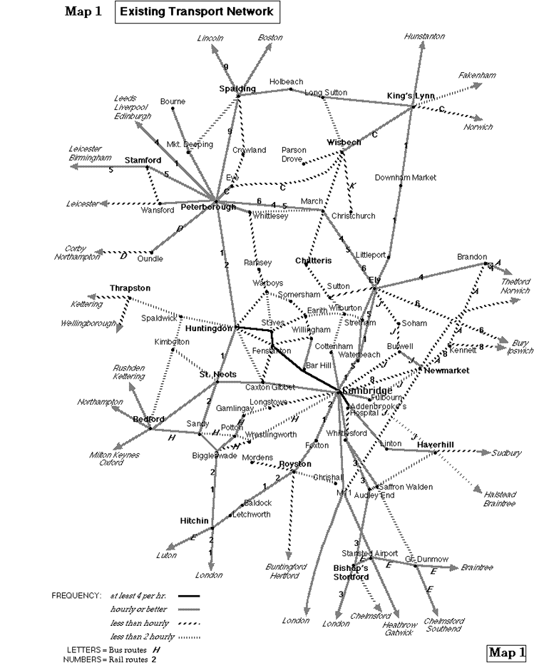
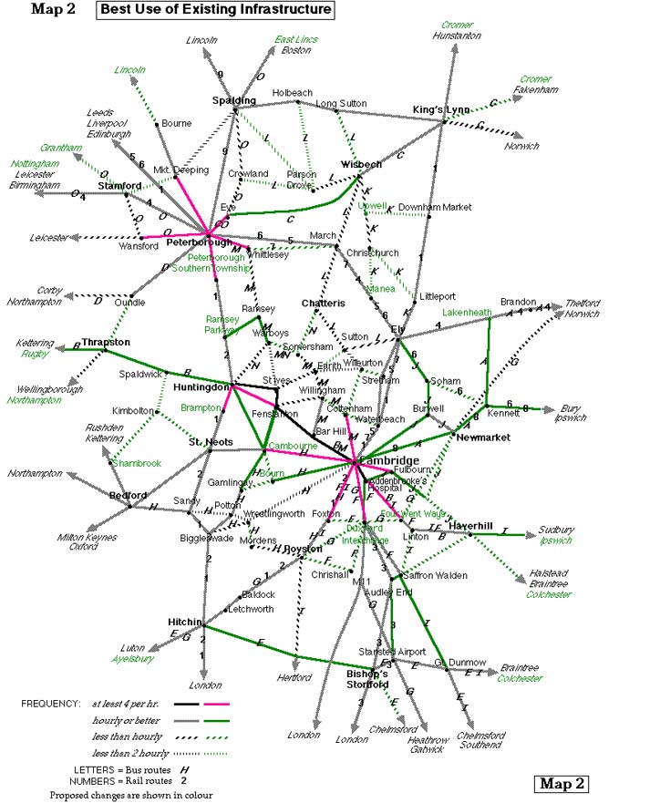
These are mainly of the ``carrot'' type (see Section 4); ``stick'' type policies should be introduced locally as opportunity arises. Section S deals with the strategic network. Other policies primarily affecting Cambridge City or South Cambridgeshire are listed in Section C, while Sections E,F,H,P cover the other four districts of the county. These district proposals begin with a cross-reference to Part B. Map 1 shows the existing network; references are made as required to Map 2 (making best use of existing infrastructure) and 3 (possible rail developments; map not currently available). Not all the improvements shown in Map 2 are described here; we have concentrated on those we believe to be most important. See footnote regarding viewing of the maps.
We start with a proposed network of strategic rail and bus services which can be introduced without new infrastructure, i.e. immediately. Though many of the services are 2 hourly, overall frequencies on many corridors would be hourly (e.g. Ipswich to Birmingham by routes 6, 7, A and B).
S1. Routes from Kings Cross. Route 1 has 2 Inter-City trains per hour from London through Peterborough, one stopping at Huntingdon, and a half hourly fast train to Cambridge, continuing hourly to Kings Lynn. Route 2 has 2 semi-fast or slow trains per hour from London to Cambridge or Huntingdon, with one continuing to Peterborough. The only new proposal is the Inter-City stop at Huntingdon.
S2. Routes from Liverpool St. Route 3 runs half hourly to Tottenham (through or connecting from Stratford), Harlow, Bishops Stortford then either all stations to Cambridge by the direct route, or Stansted Airport, Audley End, Whittlesford, Cambridge and Ely. The second is a new proposal extending part of the existing Stansted Express.
S3. Cross-country services. Existing routes 4 (Norwich-Liverpool, hourly), 5 (Cambridge-Birmingham, hourly) and 6 (Ipswich-Peterborough, 2 hourly), as shown on Map 1, are reshuffled to become 4 (Norwich-Birmingham, hourly), 5 (Cambridge-Liverpool, 2 hourly), 6 (Ipswich-Liverpool, 2 hourly) and 7 (Cambridge-Peterborough, 2 hourly), as shown on Map 2. 7, a stopping service, is rerouted to Wisbech as soon as that line is available for passenger traffic (see S8). No change to 8 (Ipswich-Cambridge, 2 hourly) while 9 (Peterborough-Spalding, Lincoln or beyond, hourly) has almost all trains running at least to Lincoln. 4 might start Yarmouth or Lowestoft, 6 Felixstowe or Harwich, 8 Felixstowe or Lowestoft.
S4. Strategic bus links on A11 and A14 corridors. Route A links Kennett and Lakenheath stations frequently via Mildenhall and Lakenheath village, connecting at the ends with Routes 4, 6 and 8, and 2 hourly extension to Cambridge and Thetford, the latter via Hockwold and Weeting. Route B links Haverhill and Rugby hourly via the A14 corridor, connecting with Routes A, 1 and 8 at Cambridge, 1 at Huntingdon, and with Inter-City at Kettering and Rugby, also at the last for Birmingham.
S5. Strategic bus links from Peterborough. Route C supplements the existing 2 hourly service to Norwich via the A47 corridor to provide an hourly service to Kings Lynn, the extra journeys running through to Cromer via the coast or Fakenham. Both routes should connect at Kings Lynn for Spalding and Route 9 to Lincoln (the existing bus service is hourly, but there's no evening or Sunday service). Route D supplements the existing 2 hourly service to Northampton via Corby to provide an hourly service, the extra journeys running via Thrapston (connecting with Route B) and Wellingborough.
S6. Other strategic bus routes. At present none of three services between Cambridge and Oxford, one of which serves Stansted Airport, provides satisfactory interchanges, though we have no specific proposals to improve the network. Trains to/from Cambridgeshire should connect at Stansted Airport, Bishops Stortford and Hitchin with Route E.
We now consider how the rail network can usefully be expanded. Note that this might in due course mean that some of the above bus routes were no longer a necessary part of the strategic network. Existing rail formations and new potential routes need to be protected from incompatible developments (see 3.5).
S7. First priority should go to restoring the rail link between Cambridge, St Ives and Huntingdon (it is not clear whether policy H2 would have to be a prerequisite). The network shown on Map 2 would then be modified as follows: Route 6 diverted via St Ives, Routes 6 and 7 increased to hourly, Routes 5 and 8 withdrawn. Extra platforms may be needed at Peterborough to provide good interchange between Routes 1, 4 and 6.
S8. Other medium term developments: in Cambridgeshire, reopen the Wisbech branch to passengers (to be served by Route 7, see Map 2) and provide a curve at Newmarket (which could be used by some Route 7 trains). A key medium term development outside Cambridgeshire is to reopen the link between the East Coast Main Line and Bedford for through trains from East Anglia to Oxford and beyond via Route 10 (see Map 3). (Note: an alternative route has been suggested, via Letchworth and Bedford, but we believe this is too circuitous. But see S10.)
S9. Cross-London links. There are three currently planned or proposed which could benefit the region. These are Thameslink (extending Routes 1 and 2 beyond Kings Cross to the South Coast); Crossrail (extending Route 3 beyond Liverpool St to Central London, Paddington and westward); and the Channel Tunnel Rail Link (enabling through trains and/or interchange facilities via Kings Cross or Stratford to Continental Europe, East Kent, the West of England and South Wales). Some of these connections are likely to require domestic use of Eurostar trains (see 5.8).
S10. Stansted Airport link. If this airport continues to expand it may be vital to provide a more southerly east-west link from Colchester to Oxford via Route 11 (see Map 3). Two options are shown: the direct route (via Flitwick) and the populated route (via Luton). Either route could carry through trains from East Anglia via Cambridge and Hitchin.
S11. Two other long term proposals are Skegness-Northampton (Route 12) and Ipswich-Birmingham direct (Route 13), both shown on Map 3. Together with our light rail proposals (see C13), the above would eliminate the need for strategic bus A, B, D and E.
S12. One further recommendation not primarily affecting passenger traffic. We urge that the line between the Haven Ports and Peterborough (shown as Route E on Map 3) should be developed as a main freight link as part of the Trans European Network. This might entail electrification in the longer term; this could also benefit passenger traffic. See F1 for a possible benefit to cyclists.
As it is not clear how the above proposals would develop, for the rest of this report we ignore S7-11 except for the Cambridge to St Ives section of Route 10 (see S7).
C1. (5.6) Two possible new pedestrian routes within Cambridge are from the rail station to the riverside (through the Botanic Gardens), and along the river between Silver St and Magdalene Bridge.
C2. (9) Provide a lorry off-loading point for Cambridge.
C3. (10.1) Implement some form of entry control in Cambridge.
C4. (10.2) Park & Ride for Cambridge. As well as the City Centre this would serve Addenbrookes and possibly the Northern Fringe (see C7 and C9). The Park & Ride corridors would run out as far as Cottenham, Huntingdon, Cambourne, Foxton, Duxford Interchange (see C7) and Four Went Ways (which would be signposted off the M11). See Map 2.
C5. (11.1) We strongly oppose upgrading of radial road routes into Cambridge such as the A10, A14 and A428, as this would exacerbate the city's traffic problems. In particular we oppose a Harston by-pass; through traffic should use the A505 and M11, and local traffic Park & Ride at Foxton or a new Harston station. See also C4, C6 and C12.
C6. (6.9) New stations: see inset on Map 3, also Hinxton & Ickleton (on main map).
C7. (6.2) Duxford Interchange. This would be a combination of the existing station at Whittlesford and a new Park & Ride site (see 10.2 and C4) at Duxford just across the M11 from the Imperial War Museum (to which a footbridge would be provided). Local buses south of Cambridge would be recast to provide direct links from villages in the area between Haslingfield and Babraham, plus local buses (Route F) and long distance coaches (Route G) to destinations beyond (see Map 2). Incidentally, a high priority short term improvement would be to get Sunday trains to stop at Whittlesford; this would provide good connections with buses on route 102/3 (with no timetable change), obviating the need for service 102 to divert via Audley End station.
C8. (6.2) Royston bus station. This would serve several South Cambridgeshire villages. The situation is similar to Ely (see E1).
C9. (6.9) Cambridge local train services. In conjunction with the reopening of the line between Cambridge and St Ives (see S7), we envisage a network of stations to serve the Cambridge area: Cambridge South (for Long Road 6th Form College and Addenbrookes), Barnwell (for Chesterton Village), Cambridge North (for Chesterton Sidings), Kings Hedges (for the Science Park and Cambridge Regional College) and Histon. These (see inset on Map 3) would provide interchange with buses for Cambridge City Centre, and Park & Ride facilities - as would other stations, both on and off the St Ives line, such as Longstanton and Foxton.
C10. (6.2) Cambridge shuttle. Because of the distance between Cambridge station and city centre we recommend that the existing City Centre Shuttle be rerouted to serve the station. The provision of a frequent free service to the heart of the city would encourage people to use rail rather than road. The station should also be served by regular buses between the station and other parts of the City, and surrounding villages. Services should run throughout train operating hours, though at slack times a demand responsive service may suffice. In the evenings and on Sundays services should either be timed to connect with trains or, if this is not feasible, run at least every 20 minutes.
C11. (6.2) Suitable railheads for evening bus links include Cambridge (throughout the city and South Cambridgeshire), Royston or Shepreth or Foxton (for the A10 corridor), Whittlesford (for Linton and Haverhill), Huntingdon (for the A14 corridor including Cambridge) and Biggleswade (for Gamlingay).
C12. (6.8) Guided buses. The planned new development at Cambourne will exacerbate traffic pressures on the A428 west of Cambridge; the A14 is already under extreme pressure. Neither Cambourne nor nearby Bar Hill is easy to connect to the rail network, so as an alternative to road widening (see C5) we propose a guided busway.
We envisage that guided buses would use some of the pedestrianised streets in the historic centre of Cambridge (thus improving local access). They would leave the city either by Huntingdon Road (as normal buses) or by the ``University Corridor'' through Newnham (with guided busways where roads do not currently exist) to the Girton Interchange, then by a guided busway parallel to the A14 to Bar Hill (thus improving access to/from the Crematorium, where park & ride facilities could be provided), then by a greenfield route to Bourn Airfield (park & ride) and Cambourne, joining the A428 near Caxton Gibbet.
Guided buses would serve towns and villages along the A14 and A428 corridors, roughly between the Great Ouse and the B1040 corridor to Biggleswade. Some buses would serve Cambridge Regional College and the Science Park, so an access should be provided between the guided busway and the A14 east.
C13. (6.8) Light rail. In the long term there may be a case for a Karlsruhe style tram network in the Cambridge area, with a principal aim being to improve access to the City Centre. Tracks could join the main line network at the Northern Fringe (St Ives line), main station and in the Cherry Hinton area (Newmarket line). Beyond they would use existing main line tracks, with possible detours to serve important destinations such as Addenbrookes, the Duxford interchange (see C7) and Saffron Walden. Other long term possibilities are via Haverhill (East Anglia's largest rail-less town) to the Stour Valley and Colchester, and over the Newmarket line to Mildenhall, RAF Lakenheath and Brandon.
C14. (6.1) New bus routes between Cambridge and East Bedfordshire (Route H on Map 2) with an hourly weekday service and also Sunday buses.
C15. (6.3) Create new coordinated bus links, at least 2 hourly, from Cambridge beyond Royston, Saffron Walden and Haverhill (Route I on Map 2).
E1. (6.2) Ely bus station. This would adjoin the rail station and also serve neighbouring Tesco's. All services to or through Ely would use it, either beyond or en route to/from the city centre.
E2. (6.2) Suitable railheads for evening bus links include Cambridge (for Bottisham, Burwell and Stretham) and Ely (for Soham and Sutton).
E3. (6.9) New stations. Soham, Prickwillow, Black Bank (see F1) and Six Mile Bottom. See Map 3.
E4. (6.3) Consolidate the existing bus services between Cambridge, Newmarket and Ely via Burwell (routes 111, 116 and 122) to provide hourly services on each leg and all necessary connections at Burwell (Route J on Map 2).
F1. (7.1) Consideration should be given to providing a cycle route across the Ouse Washes embankment east of Manea. This assumes that widening is needed for electrification (see S12). If this facility isn't viable, an alternative would be to provide regular trains stopping at Manea and a reopened Black Bank station (see E3), with adequate facilities for cyclists.
F2. (11.1) To remove Long Sutton port traffic from Wisbech, we suggest either a new A47-A17 link east of the River Nene, preferably combined with an extension of the existing March-Wisbech railway (see Map 3), or an upgrade of the River Nene, with terminal facilities in Wisbech for larger ships.
F3. (6.2) Existing bus 360 (Wisbech-Christchurch via Outwell) should be extended to provide rail links (Route K on Map 2). The 1-2 hourly service should have through ticketing, interavailable between all three railheads (also, for Wisbech passengers, March).
F4. (6.2) Suitable railheads for evening bus links include Peterborough, Kings Lynn, Downham Market or March (for Wisbech area) and Ely or March (for Chatteris area).
F5. (6.3) Improved bus link (1-2 hourly) between Sutton Bridge (for Spalding) and Ely with a connection for Huntingdon (see H7). This should be supplemented by extra buses from Wisbech to, or connecting for, Spalding. See Route L on Map 2.
H1. (10.2) Park & Ride for Huntingdon, with corridors running to St Ives, Cambridge and Brampton. See Map 2.
H2. (11.1) Remodel the local road network as follows. Divert the A14 between Godmanchester and the A1 to run south of the A141, taking care to minimise impact on the sensitive Ouse Valley. Narrow the existing road through Huntingdon; part of the formation could be used to restore the rail link between Cambridge, St Ives and Huntingdon (see S7), and to provide an access to the A141 for Huntingdon and Hinchingbrooke, enabling Godmanchester bridge to be closed except for buses.
H3. (11.1) We oppose capacity improvements on the A1 and A14 such as the current scheme to upgrade the A1 to motorway between Alconbury and Peterborough (see 3.2). This scheme will not only destroy rights of way but waste money, as if there's sufficient traffic to justify it its cost will be vastly inflated by the DBFO procedure, and the traffic will overwhelm other roads in the county. We would like to see the Government try to buy its way out of this scheme. However, we would support adaptation of the A1 and A14 to provide grade separation, if adequate crossings are provided for footpaths and bridleways, and local access to villages maintained or restored.
H4. (11.1) We oppose the current proposals for a Papworth by-pass, which will encourage traffic to use this route as a ``rat run'' to avoid the A14. However, there is a case for remodelling the existing road network to encourage through traffic to use the B1040 and A428.
H5. (6.2) Suitable railheads for evening bus links include Huntingdon (district wide) and St Neots (for the Ouse Valley).
H6. (6.9) New stations. Ramsey Parkway, St Ives, Offord and Hemingford/Houghton. See Map 2. The last should have no public road access because of the sensitivity of the area, though it could be the nucleus of a cycleway network. Ramsey Parkway should be considered as an essential precondition of the proposed expansion of Ramsey; possible sites are RAF Alconbury (depending on development there), Wood Walton and Holme.
H7. (6.1) Fill in the ``missing link'' between Warboys, Somersham and Chatteris. Our recommendation (see Map 2) is for weekday buses between Cambridge and Peterborough via Route M, and between Huntingdon and Chatteris via Route N, connecting with each other and with Route L (see F5). Each would be 2 hourly with extra buses on some sections.
H8. (6.2) Provide a ``workplace interchange'' at Papworth, with buses coming in from all the surrounding villages and, after connecting with one another, continuing to towns such as Cambridge, St Ives, Huntingdon, St Neots, Biggleswade and Royston.
H9. (5.6) Provide an off-road walking route from Huntingdon centre to the Hinchingbrooke area, including the hospital, country park and school.
H10. (7.1, 10.4) Provide a new river crossing south of Needingworth. Options include a road to Over (which would make it easier to provide a good area bus network) and a cycleway between Holywell and Fen Drayton.
H11. (6.2) St Neots town services to include station link.
P1. (10.2) Park & Ride for Peterborough, with corridors running to Whittlesey, Eye, Market Deeping, Wansford and Peterborough Southern Township. See Map 2.
P2. (11.1) We oppose the proposed A16/A43 Stamford Relief Road through Burleigh Park (a landscape of national importance); instead we would prefer a route further south which could also be used by traffic between the A1 (south) and A47 (west), thus avoiding the need for a full interchange at Wansford.
P3. (6.2) A suitable railhead for evening bus links is Peterborough (district wide).
P4. (6.9) New stations. Peterborough Southern Township, Peakirk (serving the bird reserve), Helpston and Walton/Bretton. See Map 3.
P5. (7.3) New pedestrian link between Westgate and Peterborough rail station. The existing footbridge from Queensgate Shopping Centre is unsatisfactory as it goes through a car park and is closed outside shopping hours.
P6. (6.3) Create new coordinated bus links from Peterborough beyond Spalding, Bourne and Stamford (Route O, see Map 2).
note: for clarity, the maps are approximately A3 size (dependent on monitor resolution). Some programs, such as JPEGView , are liable to shrink maps to the size of the screen. Its 'crop and zoom' facility can be used to expand selected sections to full size. Browsers such as Netscape display at full size, and the entire maps can be viewed by scrolling